

How to Kiteboard Nantucket
-
One of the best places to ride on Nantucket is Pocomo Point. Accessible by car and offering a public launching point within the harbor that anyone can get to, it works in a broad range of wind directions. When you come to the end of Pocomo Road, reach the parking lot, and walk down to the waterfront, you'll quickly know why it is such an incredible spot.
The point sticks out in the Head of Nantucket Harbor, forming a large slick protected on one side and choppy waves on the other. At high tide, the water can come up and limit the amount of space on the beach, so be wary of where you leave your gear and what the tide is doing. You'll also want to be aware of whether the tide is going with or against the wind, as it can make it harder/easier to go upwind and effects your kite size selection.
Please Note!! Pocomo is a limited launch/land spot in July & August. It is a privilege to get to use the spot so please be sure to stay away from beachgoers!
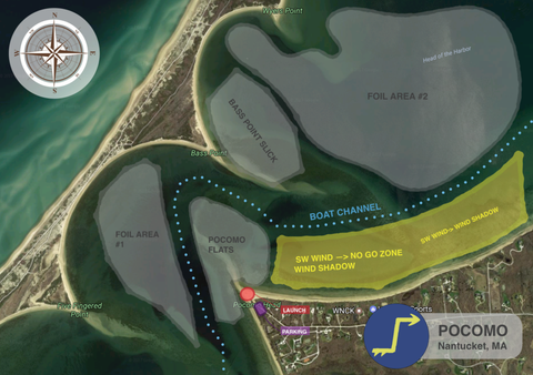

Figure 1 Figure 2 WIND
Best Months: May, June, July, August, September, October
Best Direction: SW, W
Main Direction: SW
Other Rideable Directions: NW, N, NEHYDRO/GEO
Type of Riding: Twintip, Surfboard, Hydrofoil
Type of Launch: The size of the launch depends on the tide. At low tide there is a large beach to rig on, while at high tide there is less space.
Hazards: Shells, boats, bystanders
Restricted Riding Area: (see Figure 2) July & August
Type of Water: Flat Water Slick, ChopDIRECTIONS
Follow Pocomo Road all the way to the end where you'll find a dirt parking lot. Walk down the dune to the north to access the launch.
-
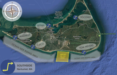
Home to the best oceanside riding in New England, the South Side of Nantucket can produce some incredible downwinders and breaking wave conditions. Tom Nevers, Cisco, & Madaket are three great options for public access points throughout the south shore. If you are going to ride the south side, be sure that you are a confident rider who can handle getting out past surf and other breaking waves.
All of the beaches along the South Side are beautiful in their own right. As the sand moves along with storms, you will find the beach can grow and shrink in a specific spot by day. While riding, be wary of shoals and sandbars and always have your exit route planned. Additionally, South Side beaches are used heavily throughout the seasons, so you'll need to watch out for other beachgoers, both in and out of the water, and make sure to respect everyone else on the beach.
One of our favorite things to do is to go on long downwinders along the southern shore. If you go, be sure to go with more than one person, let people (outside of your group too) know the float plan, and set up alternate plans in case something goes wrong.

WIND
Best Months: May, June, July, August, September, October
Best Direction: SE, SSE, S, W, SW, WNW
Main Direction: SE
Other Rideable Directions: EHYDRO/GEO
Type of Riding: Twintip, Surfboard
Type of Launch: The size of the launch depends on the tide. At low tide there is a large beach to rig on while high tide provides less space.
Hazards:Shells, Boats, Bystanders, Large Swell
Nantucket Airport: South Side downwinders are one of the best things you can do while kitesurfing on Nantucket. That being said, the Nantucket Airport runway ends directly on the shoreline of Nantucket on Nobadeer Beach. There is a two mile radius exclusion zone around the airport – be prepared to either end your downwinder prior to entering the zone, land your kite and walk past it, or ride two miles offshore to stay clear of the zone. See above map.
Type of Water: Flat Water Slick, ChopDIRECTIONS
Madaket: Follow Madaket Ave towards the ocean. Take the last Left onto Chicago St. then park in the dirt lot by the water.
Cisco: Follow Cisco Beach Access Rd to the large dirt parking lot at the end.
Tom Nevers: Follow Tom Nevers Road all the way to the end. Take a right at the first fork and follow the road around the baseball field and outdoor hockey rink. Once you pass the rink park, you'll see the dirt parking lot by the water.
-
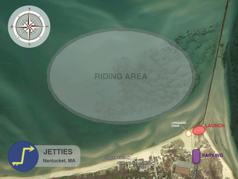
Jetties is a lesser known spot that is a great place to take your first oceanside session. Just down the beach from the Brant Point Lighthouse, Jetties Beach has a public parking space right in front of the beach. While at first all you may see are the dunes and houses surrounding you from the parking lot, if you walk down the path towards the ocean you will find the beautiful riding spot we call Jetties Beach.
On the north facing shore of Nantucket, Jetties will work in pretty much any north facing wind. Named Jetties for the large seawall that protrudes north and forms the entrance to Nantucket Harbor, there is a large sandbar that sticks out with the jetty and softens the impact of approaching waves. The result is milder to more mellow waves that are perfect to jump off of and try your first really hard turns on waves on the oceanside.
Jetties is a public access beach that gets a lot of beachgoers during the summer time. Be extremely cautious and aware of other people using the beach and ask permission and the rules of the road from any lifeguards or locals before doing anything. Be sure to stay away from the jetty itself as it can be covered with barnacles and is unforgiving if you get caught in it.

WIND
Best Months: May, June, July, August, September, October
Best Direction: N, NE
Main Direction:NE
Other Rideable Directions:NWHYDRO/GEO
Type of riding:Twintip, Surfboard, Hydrofoil
Type of Launch: The size of the launch depends on the tide. At low tide there is a large beach to rig on. At high tide there is less space.
Hazards: Shells, Boats, Bystanders
Type of Water: Flat Water Slick, ChopDIRECTIONS
Follow Bathing Beach Rd all the way to the end. Park in the large lot at the end and walk to the beach. Enjoy!
-
Accessible by boat or by kiting over from Pocomo Point, Bass Point is one of the best flat water spots to kiteboard on island. Best in a southwest breeze, a massive flat water slick forms allowing for big jumps and unhooked riding on the leeward side of the Point. The spot is off the fifth finger sticking out from Coatue and is directly across from Pocomo Point. If you launch at Pocomo, it is a short hop over to Bass Point after launching.
This is a spot that is extremely popular during the heat of the season for boaters and kiters alike. If arriving by boat, be sure to anchor well north of the end of the point to prevent your boat from being in the riding area near the tip of the point. Also, be wary of what the tide is doing and adjust your anchor line accordingly – no one likes having a beached boat after an amazing session.
As you ride at Bass Point, please be wary of the aforementioned rules of the road. Stay clear of other beachgoers. Pick up anything you brought with you (or even better, pick up something extra) and respect the privilege to ride there. Lastly, be aware of the riding protocol – people ride in laps with the right of way generally going to a rider’s left closest to shore. When you jump and ride be cautious of getting in other people’s way.


WIND
Best Months: May, June, July, August, September, October
Best Direction: SW, W
Main Direction:SW
Other Rideable Directions: NW, N, NE, E, SE, SHYDRO/GEO
Type of Riding: Twintip, Surfboard, Hydrofoil
Type of Launch: The size of the launch depends on the tide. At low tide there is a large beach to rig on. At high tide there is less space.
Hazards: Shells, Boats, Bystanders
Type of Water: Flat Water Slick, ChopDIRECTIONS
The only way to access this spot is by boat or kiting across the Harbor from Pocomo. If you kite across, keep an eye on the weather and wind so that you can make it back across at the end of your session or else you will get stranded and have a very long walk/swim back.


-
One of the best places to ride on Nantucket is Pocomo Point. Accessible by car and offering a public launching point within the harbor that anyone can get to, it works in a broad range of wind directions. When you come to the end of Pocomo Road, reach the parking lot, and walk down to the waterfront, you'll quickly know why it is such an incredible spot.
The point sticks out in the Head of Nantucket Harbor, forming a large slick protected on one side and choppy waves on the other. At high tide, the water can come up and limit the amount of space on the beach, so be wary of where you leave your gear and what the tide is doing. You'll also want to be aware of whether the tide is going with or against the wind, as it can make it harder/easier to go upwind and effects your kite size selection.
Please Note!! Pocomo is a limited launch/land spot in July & August. It is a privilege to get to use the spot so please be sure to stay away from beachgoers!
Figure 1 Figure 2 WIND
Best Months: May, June, July, August, September, October
Best Direction: SW, W
Main Direction: SW
Other Rideable Directions: NW, N, NEHYDRO/GEO
Type of Riding: Twintip, Surfboard, Hydrofoil
Type of Launch: The size of the launch depends on the tide. At low tide there is a large beach to rig on, while at high tide there is less space.
Hazards: Shells, boats, bystanders
Restricted Riding Area: (see Figure 2) July & August
Type of Water: Flat Water Slick, ChopDIRECTIONS
Follow Pocomo Road all the way to the end where you'll find a dirt parking lot. Walk down the dune to the north to access the launch.
-
Home to the best oceanside riding in New England, the South Side of Nantucket can produce some incredible downwinders and breaking wave conditions. Tom Nevers, Cisco, & Madaket are three great options for public access points throughout the south shore. If you are going to ride the south side, be sure that you are a confident rider who can handle getting out past surf and other breaking waves.
All of the beaches along the South Side are beautiful in their own right. As the sand moves along with storms, you will find the beach can grow and shrink in a specific spot by day. While riding, be wary of shoals and sandbars and always have your exit route planned. Additionally, South Side beaches are used heavily throughout the seasons, so you'll need to watch out for other beachgoers, both in and out of the water, and make sure to respect everyone else on the beach.
One of our favorite things to do is to go on long downwinders along the southern shore. If you go, be sure to go with more than one person, let people (outside of your group too) know the float plan, and set up alternate plans in case something goes wrong.
WIND
Best Months: May, June, July, August, September, October
Best Direction: SE, SSE, S, W, SW, WNW
Main Direction: SE
Other Rideable Directions: EHYDRO/GEO
Type of Riding: Twintip, Surfboard
Type of Launch: The size of the launch depends on the tide. At low tide there is a large beach to rig on while high tide provides less space.
Hazards:Shells, Boats, Bystanders, Large Swell
Nantucket Airport: South Side downwinders are one of the best things you can do while kitesurfing on Nantucket. That being said, the Nantucket Airport runway ends directly on the shoreline of Nantucket on Nobadeer Beach. There is a two mile radius exclusion zone around the airport – be prepared to either end your downwinder prior to entering the zone, land your kite and walk past it, or ride two miles offshore to stay clear of the zone. See above map.
Type of Water: Flat Water Slick, ChopDIRECTIONS
Madaket: Follow Madaket Ave towards the ocean. Take the last Left onto Chicago St. then park in the dirt lot by the water.
Cisco: Follow Cisco Beach Access Rd to the large dirt parking lot at the end.
Tom Nevers: Follow Tom Nevers Road all the way to the end. Take a right at the first fork and follow the road around the baseball field and outdoor hockey rink. Once you pass the rink park, you'll see the dirt parking lot by the water.
-
Jetties is a lesser known spot that is a great place to take your first oceanside session. Just down the beach from the Brant Point Lighthouse, Jetties Beach has a public parking space right in front of the beach. While at first all you may see are the dunes and houses surrounding you from the parking lot, if you walk down the path towards the ocean you will find the beautiful riding spot we call Jetties Beach.
On the north facing shore of Nantucket, Jetties will work in pretty much any north facing wind. Named Jetties for the large seawall that protrudes north and forms the entrance to Nantucket Harbor, there is a large sandbar that sticks out with the jetty and softens the impact of approaching waves. The result is milder to more mellow waves that are perfect to jump off of and try your first really hard turns on waves on the oceanside.
Jetties is a public access beach that gets a lot of beachgoers during the summer time. Be extremely cautious and aware of other people using the beach and ask permission and the rules of the road from any lifeguards or locals before doing anything. Be sure to stay away from the jetty itself as it can be covered with barnacles and is unforgiving if you get caught in it.
WIND
Best Months: May, June, July, August, September, October
Best Direction: N, NE
Main Direction:NE
Other Rideable Directions:NWHYDRO/GEO
Type of riding:Twintip, Surfboard, Hydrofoil
Type of Launch: The size of the launch depends on the tide. At low tide there is a large beach to rig on. At high tide there is less space.
Hazards: Shells, Boats, Bystanders
Type of Water: Flat Water Slick, ChopDIRECTIONS
Follow Bathing Beach Rd all the way to the end. Park in the large lot at the end and walk to the beach. Enjoy!
-
Accessible by boat or by kiting over from Pocomo Point, Bass Point is one of the best flat water spots to kiteboard on island. Best in a southwest breeze, a massive flat water slick forms allowing for big jumps and unhooked riding on the leeward side of the Point. The spot is off the fifth finger sticking out from Coatue and is directly across from Pocomo Point. If you launch at Pocomo, it is a short hop over to Bass Point after launching.
This is a spot that is extremely popular during the heat of the season for boaters and kiters alike. If arriving by boat, be sure to anchor well north of the end of the point to prevent your boat from being in the riding area near the tip of the point. Also, be wary of what the tide is doing and adjust your anchor line accordingly – no one likes having a beached boat after an amazing session.
As you ride at Bass Point, please be wary of the aforementioned rules of the road. Stay clear of other beachgoers. Pick up anything you brought with you (or even better, pick up something extra) and respect the privilege to ride there. Lastly, be aware of the riding protocol – people ride in laps with the right of way generally going to a rider’s left closest to shore. When you jump and ride be cautious of getting in other people’s way.
WIND
Best Months: May, June, July, August, September, October
Best Direction: SW, W
Main Direction:SW
Other Rideable Directions: NW, N, NE, E, SE, SHYDRO/GEO
Type of Riding: Twintip, Surfboard, Hydrofoil
Type of Launch: The size of the launch depends on the tide. At low tide there is a large beach to rig on. At high tide there is less space.
Hazards: Shells, Boats, Bystanders
Type of Water: Flat Water Slick, ChopDIRECTIONS
The only way to access this spot is by boat or kiting across the Harbor from Pocomo. If you kite across, keep an eye on the weather and wind so that you can make it back across at the end of your session or else you will get stranded and have a very long walk/swim back.
